

Sepik Soiree Luxury Adventure Cruise (from Cairns)
- Duration
- 11 Days
- Prices:
- On request


Cruise to the remote islands of Papua New Guinea. Trade for exquisite wood carvings at riverside markets on the Sepik River, snorkel to spot manta rays and barracudas in the turquoise blues of the Hermit Atoll and cast a line for sailfish off Rambutyo Island.

This 12-day luxury cruise through Papua New Guinea is a voyage of contrast, offering you a breathtaking snapshot of remote island paradises.
Fly from Cairns to Kavieng, the capital of New Ireland in Papua New Guinea, and embark on the True North. The True North is a luxury cruise vessel that carries a maximum of 36 passengers. It’s fully equipped with an upscale bar, lounge, dining room and observation deck, as well as an onboard helicopter. It’s well-suited for maximum comfort as you explore the remote islands of Papua New Guinea.
From Kavieng, head to the Vitu Islands, a small set of volcanic islands north of New Guinea. Formerly known as the French islands, many of the Vitus are uninhabited and are a perfect spot to get acquainted with the relaxing tempo of Papua New Guinea. Snorkel or dive to see barracuda, dogtooth tuna and sharks in the reefs. Relax in a hot spring on the Narage Islands and examine ancient carved stone artifacts on Unea Island.
On Rambutyo Island, enjoy a performance of locals dancing and playing garamut drums. Rambutyo is an ideal spot to cast a line for the incredible sailfish. Just be warned: sailfish are very difficult to catch as they can swim 100 metres in just over four seconds and are known to jump metres out of the water. If sailfish prove elusive, head to Ponam Island to try your hand at catching yellowfin tuna and snapper. It’s also a great spot for scuba diving.
The Hermit Islands are a rarely-visited coral atoll in Papua New Guinea. Treat yourself to the islands’ remote pleasures. On Luf Island, the only inhabited island, trade goods with friendly locals or sit on the water’s edge and gaze into the crystal clear waters to see the coral reef running along the ocean floor. Snorkel through the clam gardens and see the abundant sea life, including reef sharks, manta and mobula rays, turtles and barracudas. If you’re lucky, you might also glimpse some of the islands’ deer that were introduced to the country by German colonists.
The Ninigo Islands are over three dozen islands forming a coral atoll in the Bismarck Archipelago. Explore the abundant waters and see locals race their canoes. After exploring the islands, head up the Sepik River, the longest river on the island of New Guinea. The Sepik is also one of the largest freshwater systems in Pacific Asia. Trade for wood carvings, clay pottery and other local arts and crafts at the waterside markets of the Angoram Township. Photograph the incredible architecture of the stilt village on Kambaraumba Lake. Explore the verdant rainforest that covers the landscape and take a helicopter flight over the region to get a glimpse of the island’s grandeur.
End your cruise with a visit to Bagabag Island, a white sand island full of cacao and coconut plantations. The site of a dormant volcano, Bagabag is home to around 3,000 inhabitants who live in four villages. Enjoy the company of the locals and enjoy drinks as you watch the sunset on Christmas Bay.
This cruise around the islands and down the Sepik River of Papua New Guinea is a truly rare adventure you’ll cherish for the rest of your life.
- Duration
- 11 Days
- Prices:
- On request
Itinerary View Trip Map
Fly to Kavieng and Embark
Your "welcome aboard" is in the vibrant city of Cairns. One of the crew members will escort you aboard North Star's very own charter aircraft! Now sit back and enjoy the comfortable flight to Kavieng. As soon as you step off the plane you will begin to reshape your impressions of the "land of the unexpected". Perhaps the clean and fresh sea breezes will take you by surprise, or will it be the huge smiles of locals so eager to welcome you to their island paradise. After clearing customs, you will be transferred to the on-board luxury of the True North and, the delights of it's renowned galley. Enjoy a welcome aboard lunch before you visit a local island resort.
| Meal Plan | Lunch and Dinner |
|---|---|
| Duration | 10 Nights |
| Accommodation |
True North |
| Location | View map |
-

True North
The True North is purpose built to sail deep into the very heart of wilderness- we visit areas that larger ships simply cannot access. Our itineraries specifically exclude lengthy periods at sea and feature frequent daily excursions and, an Australian crew that will uniquely chaperone …
The True North is purpose built to sail deep into the very heart of wilderness- we visit areas that larger ships simply cannot access. Our itineraries specifically exclude lengthy periods at sea and feature frequent daily excursions and, an Australian crew that will uniquely chaperone your holiday experience.
Facilities
- Bar
- Dining Room
- Lounge(s)
- Sundeck
Photo gallery
Photo 1 of 1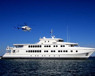
Islands around Kavieng
The many islands around Kavieng and New Hanova are a cruise highlight. A morning sing sing will be a memorable event as every man, woman and child turns out in welcome. Off the beach you find ships, planes and even submarines wrecked in shallow water and beyond the reef it's time to encounter a marauder of another kind! And, what a place for diving and snorkeling!
| Meal Plan | Breakfast, Lunch and Dinner |
|---|
Vitu Islands
The Vitu Islands are a volcanic group with an area of 96 square km located in the Bismarck Archipelago. Formerly called the French Islands, the group is also sometimes known as the Witu Islands. The islands are volcanic ocean peaks and although they are reef-ringed, they are not atolls and therefore highly fertile. The group is the chief copra centre of Papua New Guinea, although the main crop harvested is now cocoa (due to the depressed prices available for copra). Garove (or Big Witu) and Unea (Bali) are the largest islands.
The islands are situated north west of the Talasea Peninsula on the north coast of New Britain with Unea lying some 40 nautical miles south east of the main group and the remaining islands - Mundua situated 7 miles NW of Garove, and Narage some fifteen miles NW of Mundua. The final extension of the chain being the Attilian Reef which is further NW of Narage and all but totally submerged making it dangerous to shipping.
Narage Island is a post-eruption volcanic remnant measuring just 210,000 m2 - prior to the eruption in 1892-3 it measured more than 600,000 m2! The tsunami from this explosion wiped-out all but two persons in Munda's lowest-lying village (they were absent on Garove) and was causative to a major population reduction over a wide area on the north coast of New Britain. Narage is now shrouded in forest but not far from the shoreline there is a pool of boiling water, providing evidence of more recent volcanic history. In German colonial times, apart from the Kokopo area, the Vitu's were the stamping ground and major enterprise of the American-Samoan, Queen Emma, whose manager, a Dane named Peter Hansen, became quite famous for his retinue of concubines, some 26 in number!
When the Germans were expulsed post World War I the island group was acquired by the trading group Burns Philp. Langu Plantation was ceded by Burns Philp to the Coote family after World War II as compensation following the execution of their family head (and Burns Philp store manager) by the Japanese after he refused to give the invaders keys to Burns Philp's facilities in Rabaul. The Perhafen mission was established inside the caldera which forms the bulk of Garove, a wise choice considering the island's exposure to sea state - the island comprising at places only the precipitous higher ground of the caldera rim. The helicopter will provide a bird's eye view of the entire island group whilst the ship's expedition boats will deliver guests ashore for historical and cultural tours. The surrounding reef will lure the fishers, snorkellers and divers.
Vitu's remote coral reefs remain largely unexplored. Few divers have visited this area and many reefs remain un-dived. The visibility is usually superb and pelagic fishes are abundant. Grey reef sharks, silvertip sharks, dog-tooth tuna, rainbow runners and barracuda are seen on most dives. The fish assemblages on these reefs are distinctly oceanic in composition and a number of species that are rare closer inshore are very abundant here. "Krakafat" is a dive site of particular note - a sea of schooling barracuda, dog tooth tuna, trevally and everything in between. Other sites worthy of exploration include "Dickies Nob", "Barneys" and the "Arches" at nearby Ningau Island.
| Meal Plan | Breakfast, Lunch and Dinner |
|---|
Rambutyo Island
This morning you wake in Manus Province - very few travellers make it to this remote part of Papua New Guinea. The province consists of several island groups including the Horno Islands, the Admiralty Islands (including Manus Island), the Hermit Islands, Ninigo Islands and Wuvulu Island. The combined land area of the province is just 2,100 square kilometres however 220,000 square kilometres of sparkling sea surrounds! Some 45,000 people live within the province boundaries.
The name Manus is a traditional name for a group of fishing people who inhabit the coastal areas of Manus Island. The name differentiates them from other groups with differing customs and languages. These people were seafarers and traders. The outstanding feature of their society was individualism and self-reliance. The most cohesive unit was the clan; a number of clans would make up a village, but they retained their separate identities with-in the village. Each clan would have a men's house which was built by the most powerful person in the clan. Around this would be a number of family houses. Each house was under the protection of a recently deceased male relative whose skull was kept within the house. The spirit of the deceased was potent for as long as good fortune visited the person who gave the skull shelter. The skull was discarded when the spirit was no longer effective.
Apart from this ancestral protection there was no organized religion of worshipping deities. Truth and respect for property were highly valued attributes and it was through the spirits that this code was maintained. The influence of Christian Missionaries and taking on of 'western behaviour' has changed some of these outlooks and customs. Today the dead are buried in communal or private cemeteries. Change has also come in the form of new commercial pursuits - today the province largely relies on coconut cultivation and bech de mer (sea cucumber) fishing. The area is renowned for scuba diving and features colourful marine life, coral reefs, shipwrecks, and clear water.
During the morning you visit the island of Rambutyo - the second largest island (after Manus) in the Admiralty Islands. The island lies 40 kilometres to the southeast of Manus and here you might encounter traditional garamut (split drum) dancers. There will also be opportunity for some short walks and, spectacular helicopter flights over the island group.
In the afternoon you will move to the northern end of Rambutyo - the fringing reefs here are amongst some of the most spectacular you see anywhere in PNG with very high density coral cover and spectacular walls dropping into deep water. The mosaic of small islands in the area offers a wonderful backdrop and provides a wide range of different habitats to explore. Oceanic currents move gently through the passes allowing us a free ride as we observe the amazing biodiversity of these marine communities. Sailfish are also caught in the surrounding waters.
| Meal Plan | Breakfast, Lunch and Dinner |
|---|
Ponam Island
An entire day devoted to beautiful Ponam Island. Ponam played a major role in World War II. The island was occupied by Japanese forces in 1942 and retaken by Allied forces in 1944. American "Seabees" immediately constructed an airfield which was then handed over to the British Royal Navy. The British named the airfield HMS Nabaron and used it as a forward operations base. After encountering the enemy, it was not uncommon for damaged aircraft to crash when attempting to land and today the wreckage of several planes can be found in the surrounding waters. Of particular interest is Ensign Jensen's plane. The naval flyer was the only pilot to report a full-strength Japanese convoy that would have otherwise remained undetected. Unfortunately he was later killed when his plane crashed during a take-off from Ponam and the wreckage can be seen in a lagoon on the east side of the island. The terrestrial remnants of HMS Nabaron should attract the attention of the shore parties whilst the snorkellers will be keen to explore the plentiful bommies and coral outcrops found inside the Manus Barrier Reef. Coral cover is dense and brightly coloured butterfly fish and parrotfish are common.
Game fishing for marlin, yellow fin tuna, trevally and mackerel is possible and bottom fishing can produce quality catches of snapper.
Ponam is adjacent to the longest coral reef in Manus Province providing plenty of opportunity for SCUBA diving. The ship's helicopter will again swing into action offering a unique prospective of the island's many lagoons and, nearby Manus Island. There may even be time for a romantic stroll along your very own beach complete with coconut palms and a shimmering South Pacific sunset.
| Meal Plan | Breakfast, Lunch and Dinner |
|---|
Hermit Islands and Luf Island
Today you begin to visit a region that was highly rated by the underwater explorer Jean-Michel Cousteau.
The Hermit Islands form a 22 kilometre long barrier reef. They are renowned for their clam gardens and the snorkelling is truly spectacular. The gently sloping reef edge disappears into the blue depths with visibility usually exceeding 40m, allowing excellent views of the marine life that inhabits the reef edge. Sharks, manta rays, turtles and large schools of barracuda and trevally all reside here along with the usual array of colourful reef fishes and invertebrates. For the divers - The Hermits also feature incredible reef formations where large schools of mobula rays, snapper, trevally and grey reef sharks are encountered! Fresh ocean currents also make for riproaring dives in channels chocked with giant sea fans and soft coral formations. Marlin and sailfish are also known to occur and hopefully the hikers will catch a glimpse of deer introduced by German colonists.
In the afternoon the expedition boats will land at Luf Island - the only inhabited island in the Hermits. Join the crew as you meet the locals and experience local village life.
| Meal Plan | Breakfast, Lunch and Dinner |
|---|
Ninigo Islands
The Ninigo Islands are a large open-atoll structure surrounded by several smaller atoll formations. In total there are 7 atolls with around 50 small islets - plenty of opportunity for exploration.
The largest component of islands forms a 34 km long by 18 km wide atoll that is open on its western side. The major island within the group is Mal, located at the southern end of the outer reef. Other islands on the reef include: Hepi, Lau, Pelipa, Ahu, Sawapil, Chauch, Menan, Longan, Nahanu, Hepisasa, Chacheon, Maichuch, Potaminam, Amik, Puol, Pisa, Ngi, Onia, Wahangahun, Sabucho, Pihun, Keholl, Kamochin, Sand and Nunu. Within the lagoon are the islands of Pingilap, Talil, Hottom, Bahanat and Amot. The diving here is some of the best encountered in PNG. True North will endeavour to explore as many of these picture-perfect islands as you can and it's likely that the day will be filled with magical snorkelling and diving experiences, leviathan struggles with rod and reel, exhilarating dips in the crystal clear lagoons and romantic strolls along the ever-present palm fringed beaches.
| Meal Plan | Breakfast, Lunch and Dinner |
|---|
The Sepik
The Sepik - as far as adventure is concerned, it doesn't get much better. Just the name conjures up excitement. The Sepik River is the longest river in Papua New Guinea and, one of the great river systems of the world. It has a large catchment area and supports numerous landforms including swamplands, tropical rainforests and mountains. Biologically, the river system is possibly the largest uncontaminated freshwater wetland system in the Asia-Pacific region.
The river's total length is 1,126 kilometres and it has a drainage basin of over 80,000 square kilometres! There is a 5-10 kilometer wide belt of active meanders along most of the river's course and a floodplain up to 70 kilometers wide includes extensive backwater swamps. However, unlike many other large river systems, the Sepik has no delta - it flows straight into the sea. The entire Sepik basin remains a largely undisturbed environment - there are no major urban settlements or mining and forestry activities in the river catchment.
Local villagers have lived along the river for many millennia and the river has formed the basis for food, transport and culture. European contact with the river started in just 1885 when German colonists first explored the area. In 1886 and 1887, further expeditions by steam boat were conducted by the Germans and over 600 kilometers of riverine was explored. Between 1912 and 1913 the Germans sent further expeditions to explore the river and surrounding areas. They collected flora and fauna, studied local tribes and produced the first maps. The station town of Angoram was established as a base on the lower Sepik for explorations, but with the beginning of World War I, exploration ceased.
After the war the Australian government took trusteeship of the former German colony, creating the Territory of New Guinea. During this period the Australians established a station on the middle Sepik at Ambunti and conducted further exploration. In 1935 Sir Walter McNicolls, the new administrator of the Territory of New Guinea travelled up length of the Sepik to "have a look at the river people and the kind of country along the banks".
The Japanese held the area throughout most of the Second World War. By the end of the war the Japanese had been completely surrounded however, the battle to defeat the remaining forces was hard fought and drawn out due to the terrain. The Australians eventually pushed the Japanese back to the village of Timbunke on the middle Sepik in July 1945. Eventually the Japanese were defeated and surrendered at Wewak in September 1945.
The Sepik is revered for its art. The tribes living along the river produce magnificent wood carvings and artful clay pottery. Many tribes use garamut drums in rituals; the drums are formed from long, hollowed out tree trunks carved into the shape of various totem animals. As part of an elaborate coming of age ceremony, young men are scarified with the image of a crocodile on the river bank.
The True North will arrive at the mouth of the Sepik at first light before proceeding 70 nautical miles upstream. Then it's away in the expedition boats and the helicopter for days filled with exploration and discovery. Highlights include the township of Angoram - here the waterside market presents as a fantastic opportunity to purchase local carvings. At Kambaraumba village you will be greeted by a 'sing-sing' featuring giant crocodile puppets that gyrate through crowds of dancers and drummers - truly a feast for the senses! You also explore the maze of swamps and small waterways that lead to Lake Kambaraumba and its stilt village - a community of huts, churches, schools and animal enclosures built above the waters of the lake!
| Meal Plan | Breakfast, Lunch and Dinner |
|---|
The Sepik
Today is spent exploring the Sepik
| Meal Plan | Breakfast, Lunch and Dinner |
|---|
The Sepik
Today is spent exploring the Sepik
| Meal Plan | Breakfast, Lunch and Dinner |
|---|
Disembark and Fly to Cairns
This morning you are alongside in Madang. Transfer to your charter plane and the return flight to Cairns.
| Meal Plan | Breakfast |
|---|
Other Information
DEPARTURES:
2023: Oct 19, 29; Nov 8
PRICE INCLUDES:
- Accommodation in air conditioned cabins
- All meals (10 Breakfasts + 10 Lunches + 10 Dinners)
- Non alcoholic beverages
- All activities including;
- Sight-seeing
- Swimming
- On-shore visits etc
- Fishing gear (rods, reels, handlines)
PRICE EXCLUDES:
- Travel insurance
- International and domestic airfare & airfare taxes
- Visa fees if applicable
- Items of a personal nature
- Gratuities unless otherwise stated
- All scenic helicopter flights
- Purchases from resort shop
- Alcoholic beverages
- Personal valet/laundry
- Use of satellite phones
- Internet access
TERMS AND CONDITIONS:
Prices are "from" per person based on twin/double share accommodation and for travel in low season. Seasonal surcharges and blackout dates may apply. Limited seat/spaces and all pricing is subject to change and availability. Rates for single or triple travellers are available on request - please inquire.
8 Nov 2023
× Goway special offers


